Kitabı oku: «Island Life; Or, The Phenomena and Causes of Insular Faunas and Floras», sayfa 8
We now pass into the oldest or Palæozoic formations, but find no diminution in the proofs of continental conditions. The Permian formation has a rich flora often producing coal in England, France, Saxony, Thuringia, Silesia, and Eastern Russia. Coalfields of the same age occur in Ohio in North America. In the still more ancient Carboniferous formation we find the most remarkable proofs of the existence of our present land masses at that remote epoch, in the wonderful extension of coal beds in all the known continents. We find them in Ireland, England, and Scotland; in France, Spain, Belgium, Saxony, Prussia, Bohemia, Hungary, Sweden, Spitzbergen, Siberia, Russia, Greece, Turkey, and Persia; in many parts of continental India, extensively in China, and in Australia, Tasmania, and New Zealand. In North America there are immense coal fields, in Nova Scotia and New Brunswick, from Pennsylvania southward to Alabama, in Indiana and Illinois, in Missouri, and even so far west as Colorado; and there is also a true coal formation in South Brazil. This wonderfully wide distribution of coal, implying, as it does, a rich vegetation and extensive land areas, carries back the proof of the persistence and general identity of our continents to a period so remote that none of the higher animal types had probably been developed. But we can go even further back than this, to the preceding Devonian formation, which was almost certainly an inland deposit often containing remains of fresh-water shells, plants, and even insects; while Professor Ramsay believes that he has found "sun-cracks and rain-pittings" in the Longmynd beds of the still earlier Cambrian formation.30 If now, in addition to the body of evidence here adduced, we take into consideration the fresh-water deposits that still remain to be discovered, and those extensive areas where they have been destroyed by denudation or remain deeply covered up by later marine or volcanic formations, we cannot but be struck by the abounding proofs of the permanence of the great features of land and sea as they now exist; and we shall see how utterly gratuitous, and how entirely opposed to all the evidence at our command, are the hypothetical continents bridging over the deep oceans, by the help of which it is so often attempted to cut the Gordian knot presented by some anomalous fact in geographical distribution.
Oceanic Islands as Indications of the Permanence of Continents and Oceans.—Coming to the question from the other side, Mr. Darwin has adduced an argument of considerable weight in favour of the permanence of the great oceans. He says (Origin of Species, 6th Ed. p. 288): "Looking to existing oceans, which are thrice as extensive as the land, we see them studded with many islands; but hardly one truly oceanic island (with the exception of New Zealand, if this can be called a truly oceanic island) is as yet known to afford even a fragment of any Palæozoic or Secondary formation. Hence we may perhaps infer that during the Palæozoic and Secondary periods neither continents nor continental islands existed where our oceans now extend; for had they existed, Palæozoic and Secondary formations would in all probability have been accumulated from sediment derived from their wear and tear; and these would have been at least partially upheaved by the oscillations of level, which must have intervened during these enormously long periods. If then we may infer anything from these facts, we may infer that, where our oceans now extend, oceans have extended from the remotest period of which we have any record; and, on the other hand, that where continents now exist, large tracts of land have existed, subjected no doubt to great oscillations of level, since the Cambrian period." This argument standing by itself has not received the attention it deserves, but coming in support of the long series of facts of an altogether distinct nature, going to show the permanence of continents, the cumulative effect of the whole must, I think, be admitted to be irresistible.31
General Stability of Continents with Constant Change of Form.—It will be observed that the very same evidence which has been adduced to prove the general stability and permanence of our continental areas also goes to prove that they have been subjected to wonderful and repeated changes in detail. Every square mile of their surface has been again and again under water, sometimes a few hundred feet deep, sometimes perhaps several thousands. Lakes and inland seas have been formed, have been filled up with sediment, and been subsequently raised into hills or even mountains. Arms of the sea have existed crossing the continents in various directions, and thus completely isolating the divided portions for varying intervals. Seas have been changed into deserts and deserts into seas. Volcanoes have grown into mountains, have been degraded and sunk beneath the ocean, have been covered with sedimentary deposits, and again raised up into mountain ranges; while other mountains have been formed by the upraised coral reefs of inland seas. The mountains of one period have disappeared by denudation or subsidence, while the mountains of the succeeding period have been rising from beneath the waves. The valleys, the ravines, and the mountain peaks, have been carved out and filled up again; and all the vegetable forms which clothe the earth and furnish food for the various classes of animals have been completely changed again and again.
Effect of Continental Changes on the Distribution of Animals.—It is impossible to exaggerate, or even adequately to conceive, the effect of these endless mutations on the animal world. Slowly but surely the whole population of living things must have been driven backward and forward from east to west, or from north to south, from one side of a continent or a hemisphere to the other. Owing to the remarkable continuity of all the land masses, animals and plants must have often been compelled to migrate into other continents, where in the struggle for existence under new conditions many would succumb; while such as were able to survive would constitute those wide-spread groups whose distribution often puzzles us. Owing to the repeated isolation of portions of continents for long periods, special forms of life would have time to be developed, which, when again brought into competition with the fauna from which they had been separated, would cause fresh struggles of ever increasing complexity, and thus lead to the development and preservation of every weapon, every habit, and every instinct, which could in any way conduce to the safety and preservation of the several species.
Changed Distribution proved by the Extinct Animals of Different Epochs.—We thus find that, while the inorganic world has been in a state of continual though very gradual change, the species of the organic world have also been slowly changing in form and in the localities they inhabit; and the records of these changes and these migrations are everywhere to be found, in the actual distribution of the species no less than in the fossil remains which are preserved in the rocks. Everywhere the animals which have most recently become extinct resemble more or less closely those which now live in the same country; and where there are exceptions to the rule, we can generally trace them to some changed conditions which have led to the extinction of certain types. But when we go a little further back, to the late or middle Tertiary deposits, we almost always find, along with forms which might have been the ancestors of some now living, others which are only now found in remote regions and often in distinct continents—clear indications of those extensive migrations which have ever been going on. Every large island contains in its animal inhabitants a record of the period when it was last separated from the adjacent continent, while some portions of existing continents still show by the comparative poverty and speciality of their animals that at no distant epoch they were cut off by arms of the sea and formed islands. If the geological record were more perfect, or even if we had as good a knowledge of that record in all parts of the world as we have in Europe and North America, we could arrive at much more accurate results than we are able to do with our present very imperfect knowledge of extinct forms of life; but even with our present scanty information we are able to throw much light upon the past history of our globe and its inhabitants, and can sketch out with confidence many of the changes they must have undergone.
Summary of Evidence for the General Permanence of Continents and Oceans.—As this question of the permanence of our continents or, rather, of the continental areas, lies at the root of all our inquiries into the past changes of the earth and its inhabitants, and as it is at present completely ignored by many writers, and even by naturalists of eminence, it will be well to summarise the various kinds of evidence which go to establish it.32 We know as a fact that all sedimentary deposits have been formed under water, but we also know that they were largely formed in lakes or inland seas, or near the coasts of continents or great islands, and that deposits uniform in character and more than 150 or 200 miles wide were rarely, if ever, formed at the same time. The further we go from the land the less rapidly deposition takes place, hence the great bulk of all the strata must have been formed near land. Some deposits are, it is true, continually forming in the midst of the great oceans, but these are chiefly organic and increase very slowly, and there is no proof that any part of the series of known geological formations exactly resembles them. Chalk, which is still believed to be such a deposit by many naturalists, has been shown, by its contained fossils, to be a comparatively shallow water formation—that is, one formed at a depth measured by hundreds rather than by thousands of fathoms. The nature of the formations composing all our continents also proves the continuity of those continents. Everywhere we find clearly marked shore and estuarine deposits, showing that every part of the existing land has in turn been on the sea-shore; and we also find in all periods lacustrine formations of considerable extent with remains of plants and land animals, proving the existence of continents or extensive lands, in which such lakes or estuaries could be formed. These lacustrine deposits can be traced back through every period, from the newer Tertiary to the Devonian and Cambrian, and in every continent which has been geologically explored; and thus complete the proof that our continents have been in existence under ever changing forms throughout the whole of that enormous lapse of time.
On the side of the oceans we have also a great weight of evidence in favour of their permanence and stability. In addition to their enormous depths and great extent, and the circumstance that the deposits now forming in them are distinct from anything found upon the land-surface, we have the extraordinary fact that the countless islands scattered over their whole area (with one or two exceptions only and those comparatively near to continental areas) never contain any Palæozoic or Secondary rocks—that is, have not preserved any fragments of the supposed ancient continents, nor of the deposits which must have resulted from their denudation during the whole period of their existence! The supposed exceptions are New Zealand and the Seychelles Islands, both situated near to continents and not really oceanic, leaving almost the whole of the vast areas of the Atlantic, Pacific, Indian, and Southern oceans, without a solitary relic of the great islands or continents supposed to have sunk beneath their waves.
CHAPTER VII
CHANGES OF CLIMATE WHICH HAVE INFLUENCED THE DISPERSAL OF ORGANISMS: THE GLACIAL EPOCH
Proofs of the Recent Occurrence of a Glacial Epoch—Moraines—Travelled Blocks—Glacial Deposits of Scotland: the "Till"—Inferences from the Glacial Phenomena of Scotland—Glacial Phenomena of North America—Effects of the Glacial Epoch on Animal Life—Warm and Cold Periods—Palæontological Evidence of Alternate Cold and Warm Periods—Evidence of Interglacial Warm Periods on the Continent and in North America—Migrations and Extinctions of Organisms caused by the Glacial Epoch.
We have now to consider another set of physical revolutions which have profoundly affected the whole organic world. Besides the wonderful geological changes to which, as we have seen, all continents have been exposed, and which must, with extreme slowness, have brought about the greater features of the dispersal of animals and plants throughout the world, there has been also a long succession of climatal changes, which, though very slow and gradual when measured by centuries, may have sometimes been rapid as compared with the slow march of geological mutations.
These climatal changes may be divided into two classes, which have been thought to be the opposite phases of the same great phenomenon—cold or even glacial epochs in the Temperate zones on the one hand, and mild or even warm periods extending into the Arctic regions on the other. The evidence for both these changes having occurred is conclusive; and as they must be taken account of whenever we endeavour to explain the past migrations and actual distribution of the animal world, a brief outline of the more important facts and of the conclusions they lead to must be here given.
Proofs of the Recent Occurrence of a Glacial Epoch.—The phenomena that prove the recent occurrence of glacial epochs in the temperate regions are exceedingly varied, and extend over very wide areas. It will be well therefore to state, first, what those facts are as exhibited in our own country, referring afterwards to similar phenomena in other parts of the world.
Perhaps the most striking of all the evidences of glaciation are the grooved, scratched, or striated rocks. These occur abundantly in Scotland, Cumberland, and North Wales, and no rational explanation of them has ever been given except that they were formed by glaciers. In many valleys, as, for instance, that of Llanberris in North Wales, hundreds of examples may be seen, consisting of deep grooves several inches wide, smaller furrows, and striæ of extreme fineness wherever the rock is of sufficiently close and hard texture to receive such marks. These grooves or scratches are often many yards long, they are found in the bed of the valley as well as high up on its sides, and they are almost all without exception in one general direction—that of the valley itself, even though the particular surface they are upon slopes in another direction. When the native covering of turf is cleared away from the rock the grooves and striæ are often found in great perfection, and there is reason to believe that such markings cover, or have once covered, a large part of the surface. Accompanying these markings we find another, hardly less curious phenomenon, the rounding off or planing down of the hardest rocks to a smooth undulating surface. Hard crystalline schists with their strata nearly vertical, and which one would expect to find exposing jagged edges, are found ground off to a perfectly smooth but never to a flat surface. These rounded surfaces are found not only on single rocks but over whole valleys and mountain sides, and form what are termed roches moutonnées, from their often having the appearance at a distance of sheep lying down.
Now these two phenomena are actually produced by existing glaciers, while there is no other known or even conceivable cause that could have produced them. Whenever the Swiss glaciers retreat a little, as they sometimes do, the rocks in the bed of the valley they have passed over are found to be rounded, grooved, and striated just as are those of Wales and Scotland. The two sets of phenomena are so exactly identical that no one who has ever compared them can doubt that they are due to the same causes. But we have further and even more convincing evidence. Glaciers produce many other effects besides these two, and whatever effects they produce in Switzerland, in Norway, or in Greenland, we find examples of similar effects having been produced in our own country. The most striking of these are moraines and travelled blocks.
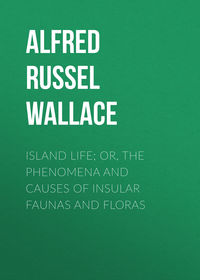
Moraines.—Almost every existing glacier carries down with it great masses of rock, stones, and earth, which fall on its surface from the precipices and mountain slopes which hem it in, or the rocky peaks which rise above it. As the glacier slowly moves downward, this débris forms long lines on each side, or on the centre whenever two glacier-streams unite, and is deposited at its termination in a huge mound called the terminal moraine. The decrease of a glacier may often be traced by successive old moraines across the valley up which it has retreated. When once seen and examined, these moraines can always be distinguished almost at a glance. Their position is most remarkable, having no apparent natural relation to the form of the valley or the surrounding slopes, so that they look like huge earthworks formed by man for purposes of defence. Their composition is equally peculiar, consisting of a mixture of earth and rocks of all sizes, usually without any arrangement, the rocks often being huge angular masses just as they had fallen from the surrounding precipices. Some of these rock masses often rest on the very top of the moraine in positions where no other natural force but that of ice could have placed them. Exactly similar mounds are found in the valleys of North Wales and Scotland, and always where the other evidences of ice-action occur abundantly.

A GLACIER WITH MORAINES.
Travelled Blocks.—The phenomenon of travelled or perched blocks is also a common one in all glacier countries, marking out very clearly the former extent of the ice. When a glacier fills a lateral valley, its foot will sometimes cross over the main valley and abut against its opposite slope, and it will deposit there some portion of its terminal moraine. But in these circumstances the end of the glacier not being confined laterally will spread out, and the moraine matter will be distributed over a large surface, so that the only well-marked token of its presence will be the larger masses of rock that may have been brought down. Such blocks are found abundantly in many of the districts of our own country where other marks of glaciation exist, and they often rest on ridges or hillocks over which the ice has passed, these elevations consisting sometimes of loose material and sometimes of rock different from that of which the blocks are composed. These are called travelled blocks, and can almost always be traced to their source in one of the higher valleys from which the glacier descended. Some of the most remarkable examples of such travelled blocks are to be found on the southern slopes of the Jura. These consist of enormous angular blocks of granite, gneiss, and other crystalline rocks, quite foreign to the Jura mountains, but exactly agreeing with those of the Alpine range fifty miles away across the great central valley of Switzerland. One of the largest of these blocks is forty feet diameter, and is situated 900 feet above the level of the Lake of Neufchatel. These blocks have been proved by Swiss geologists to have been brought by the ancient glacier of the Rhone which was fed by the whole Alpine range from Mont Blanc to the Furka Pass. This glacier must have been many thousand feet thick at the mouth of the Rhone valley near the head of the Lake of Geneva, since it spread over the whole of the great valley of Switzerland, extending from Geneva to Neufchatel, Berne, and Soleure, and even on the flanks of the Jura, reached a maximum height of 2,015 feet above the valley. The numerous blocks scattered over the Jura for a distance of about a hundred miles vary considerably in the material of which they are composed, but they are found to be each traceable to a part of the Alps corresponding to their position, on the theory that they have been brought by a glacier spreading out from the Rhone valley. Thus, all the blocks situated to the east of a central point G (see map) can be traced to the eastern side of the Rhone valley (l e d), while those found towards Geneva have all come from the west side (p h). It is also very suggestive that the highest blocks on the Jura at G have come from the eastern shoulder of Mont Blanc in the direct line h B F G. Here the glacier would naturally preserve its greatest thickness, while as it spread out eastward and westward it would become thinner. We accordingly find that the travelled blocks on either side of the central point become lower and lower, till near Soleure and Geneva they are not more than 500 feet above the valley. The evidence is altogether so conclusive that, after personal examination of the district in company with eminent Swiss geologists, Sir Charles Lyell gave up the view he had first adopted—that the blocks had been carried by floating ice during a period of submergence—as altogether untenable.33

MAP SHOWING THE COURSE OF THE ANCIENT GLACIER OF THE RHONE AND THE DISTRIBUTION OF ERRATIC BLOCKS ON THE JURA.
The phenomena now described demonstrate a change of climate sufficient to cover all our higher mountains with perpetual snow, and fill the adjacent valleys with huge glaciers at least as extensive as those now found in Switzerland. But there are other phenomena, best developed in the northern part of our islands, which show that even this state of things was but the concluding phase of the glacial period, which, during its maximum development, must have reduced the northern half of our island to a condition only to be paralleled now in Greenland and the Antarctic regions. As few persons besides professed geologists are acquainted with the weight of evidence for this statement, and as it is most important for our purpose to understand the amount of the climatal changes the northern hemisphere has undergone, I will endeavour to make the evidence intelligible, referring my readers for full details to Dr. James Geikie's descriptions and illustrations.34
Glacial Deposits of Scotland: the "Till."—Over almost all the lowlands and in most of the highland valleys of Scotland there are immense superficial deposits of clay, sand, gravel, or drift, which can be traced more or less directly to glacial action. Some of these are moraine matter, others are lacustrine deposits, while others again have been formed or modified by the sea during periods of submergence. But below them all, and often resting directly on the rock-surface, there are extensive layers of a very tough clayey deposit known as "till." The till is very fine in texture, very tenacious, and often of a rock-like hardness. It is always full of stones, all of which are of rude form, but with the angles rubbed off, and almost always covered with scratches and striæ often crossing each other in various directions. Sometimes the stones are so numerous that there seems to be only just enough clay to unite them into a solid mass, and they are of all sizes, from mere grit up to rocks many feet in diameter. The "till" is found chiefly in the low-lying districts, where it covers extensive areas sometimes to a depth of a hundred feet; while in the highlands it occurs in much smaller patches, but in some of the broader valleys forms terraces which have been cut through by the streams. Occasionally it is found as high as two thousand feet above the sea, in hollows or hill-sides, where it seems to have been protected from denudation.
The "till" is totally unstratified, and the rock-surfaces on which it almost always rests are invariably worn smooth, and much grooved and striated when the rock is hard; but when it is soft or jointed, it frequently shows a greatly broken surface. Its colour and texture, and the nature of the stones it contains, all correspond to the character of the rock of the district where it occurs, so that it is clearly a local formation. It is often found underneath moraines, drift, and other late glacial deposits, but never overlies them (except in special cases to be hereafter referred to), so that it is certainly an earlier deposit.
Throughout Scotland, where "till" is found, the glacial striæ, perched blocks, roches moutonnées, and other marks of glacial action, occur very high up the mountains to at least 3,000 and often even to 3,500 feet above the sea, while all lower hills and mountains are rounded and grooved on their very summits; and these grooves always radiate outwards from the highest peaks and ridges towards the valleys or the sea.
Inferences from the Glacial Phenomena of Scotland.—Now all these phenomena taken together render it certain that the whole of Scotland was once buried in a vast sea of ice, out of which only the highest mountains raised their summits. There is absolutely no escape from this conclusion; for the facts which lead to it are not local—found only in one spot or one valley—but general throughout the entire length and breadth of Scotland; and are besides supported by such a mass of detailed corroborative evidence as to amount to absolute demonstration. The weight of this vast ice-sheet, at least three thousand feet in maximum thickness, and continually moving seaward with a slow grinding motion like that of all existing glaciers, must have ground down the whole surface of the country, especially all the prominences, leaving the rounded rocks as well as the grooves and striæ we still see marking the direction of its motion. All the loose stones and rock-masses which lay on the surface would be pressed into the ice; the harder blocks would serve as scratching and grinding tools, and would thus themselves become rounded, scratched, and striated, as we see them, while all the softer masses would be ground up into impalpable mud along with the material planed off the rocky projections of the country, leaving them in the condition of roches moutonnées.
The peculiar characters of the "till," its fineness and tenacity, correspond closely with the fine matter which now issues from under all glaciers, making the streams milky white, yellow, or brown, according to the nature of the rock. The sediment from such water is a fine unctuous, sticky deposit, only needing pressure to form it into a tenacious clay; and when "till" is exposed to the action of water, it dissolves into a similar soft, sticky, unctuous mud. The present glaciers of the Alps, being confined to valleys which carry off a large quantity of drainage water, lose this mud perhaps as rapidly as it is formed; but when the ice covered the whole country, there was comparatively little drainage water, and thus the mud and stones collected in vast compact masses in all the hollows, and especially in the lower flat valleys, so that, when the ice retreated, the whole country was more or less covered with it. It was then, no doubt, rapidly denuded by rain and rivers, but, as we have seen, great quantities remain to the present day to tell the tale of its wonderful formation.35
There is good evidence that, when the ice was at its maximum, it extended not only over the land, but far out to sea, covering all the Scottish islands, and stretching in one connected sheet to Ireland and Wales, where all the evidences of glaciation are as well marked as in Scotland, though the ice did not of course attain quite so great a thickness.36
It is evident that the change of climate requisite to produce such marvellous effects in the British Isles could not have been local, and we accordingly find strikingly similar proofs that Scandinavia and all northern Europe have also been covered with a huge ice-sheet; while we have already seen that a similar gigantic glacier buried the Alps, carrying granitic blocks to the Jura, where it deposited them at a height of 3,450 feet above the sea; while to the south, in the plains of Italy, the terminal moraines left by the retreating glaciers have formed extensive hills, those of Ivrea the work of the great glacier from the Val d'Aosta being fifteen miles across and from 700 to 1,500 feet high.
Glacial Phenomena in North America.—In North America the marks of glaciation are even more extensive and striking than in Europe, stretching over the whole of Canada and to the south of the great lakes as far as latitude 39°. There is, in all these countries, a wide-spread deposit like the "till" of Scotland, produced by the grinding of the great ice-sheet when it was at its maximum thickness; and also extensive beds of moraine-matter, true moraines, and travelled blocks, left by the glaciers as they retreated towards the mountains and finally withdrew into the upland valleys. There are, also, in Britain, Scandinavia, and North America, proofs of the submersion of the land beneath the sea to a depth of upwards of a thousand feet; but this is a subject we need not here enter upon, as our special object is to show the reality and amount of that wonderful and comparatively recent change of climate termed the glacial epoch.
Many persons, even among scientific men, who have not given much attention to the question, look upon the whole subject of the glacial epoch as a geological theory made to explain certain phenomena which are otherwise a puzzle; and they would not be much surprised if they were some day told that it was all a delusion, and that Mr. So-and-so had explained the whole thing in a much more simple way. It is to prevent my readers being imposed upon by any such statements or doubts, that I have given this very brief and imperfect outline of the nature, extent, and completeness of the evidence on which the existence of the glacial epoch depends. There is perhaps no great conclusion in any science which rests upon a surer foundation than this; and if we are to be guided by our reason at all in deducing the unknown from the known, the past from the present, we cannot refuse our assent to the reality of the glacial epoch of the northern hemisphere in all its more important features.
In my Darwinism (pp. 344-5) I have given an additional argument founded on the comparative height and area of land with the depth and area of ocean, which seems to me to add considerably to the weight of the evidence here submitted for the permanence of oceanic and continental areas.