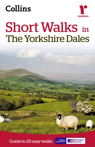
Short walks in the Yorkshire Dales
Abonelik- Hacim: 130 sayfa. 130 illüstrasyonlar
- Tür: rekreasyon / turizmDüzetme
Short Walks in
The Yorkshire Dales
Guide to 20 easy walks
Contents
Cover
Title
Short Walk locations
Introduction
How to use this book
Short walks
walk 1: Booze
3¼ miles (5.2km)
walk 2: Muker & Thwaite
3 miles (4.8km)
walk 3: Semer Water
4 miles (6.4km)
walk 4: The Waterfalls of Aysgarth & West Burton
4¾ miles (7.6km)
walk 5: Hardraw Force
3½ miles (5.6km)
walk 6: Hell Gill
4¾ miles (7.6km)
walk 7: Winder
4¾ miles (7.6km)
walk 8: Sedbergh & River Rawthey
4½ miles (7.2km)
walk 9: Middleham
2½ miles (4km)
walk 10: Coverdale
4½ miles (7.2km)
walk 11: Kettlewell & Starbotton
5½ miles (8.8km)
walk 12: Ghaistrill’s Strid & Grass Wood
4½ miles (7.2km)
walk 13: Malham Cove & Gordale Scar
4¾ miles (7.6km)
walk 14: Simon’s Seat
4 miles (6.4km)
walk 15: Attermire Scar
4½ miles (7.2km)
walk 16: Pen-y-ghent
6 miles (9.7km)
walk 17: Upper Littondale
5 miles (8km)
walk 18: Central Swaledale
3 ¾ miles (6km)
walk 19: Ingleton’s Waterfalls
4¾ miles (7.6km)
walk 20: Chapel-le-Dale
3½ miles (5.6km)
Photo credits
Copyright
About the Publisher
walk 1,
walk 2,
walk 3,
walk 4,
walk 5,
walk 6,
walk 7,
walk 8,
walk 9,
walk 10,
walk 11,
walk 12,
walk 13,
walk 14,
walk 15,
walk 16,
walk 17,
walk 18,
walk 19,
walk 20
Introduction
Walking in the Yorkshire Dales
People have walked the Yorkshire Dales almost since the first man appeared on our shores. Prehistoric hunters followed regular routes along grassy ridges and across the broad cols connecting individual dales. Later, the Romans built their roads, some of which are now used by modem traffic. Others are still recognisable as stony tracks across the fells. Drovers and packhorsemen, the ancestors of today’s long-distance lorry drivers, created green roads which can be traced for miles across the wild central moors. Corpse roads linking outlying hamlets to sanctified ground miles down the dale still exist but it is perhaps the local footpaths, connecting villages and farmsteads, which will give the most pleasure to a walker in the Dales.
Walking is a pastime which can fulfil the needs of everyone. You can adapt it to suit your own preferences and it is one of the healthiest of activities. This guide is for those who just want to walk a few miles. It really doesn’t take long to find yourself in some lovely countryside. Most of the walks are five miles or less so should easily be completed in under three hours. Walking can be anything from an individual pastime to a family stroll, or maybe a group of friends enjoying the fresh air and open spaces of our countryside. There is no need for walking to be competitive and, to get the most from a walk, it shouldn’t be regarded simply as a means of covering a given distance in the shortest possible time.
What are the Yorkshire Dales ?
The Central Pennines are cut by a series of valleys which have become known as the Yorkshire Dales. Radiating from a watershed on the mass of high ground north and east of Ribblehead, five rivers, the Swale, Ure, Nidd, Wharfe and Aire, eventually flow east into the North Sea by way of the Ouse and Humber. Three others, the Ribble, Lune and Eden, all enter the Irish Sea, to the west, as independent rivers. All have their birth on the gritstone cap of the central moors but, with the exception of the Nidd and Lune, they all flow for at least their middle sections through countryside based upon limestone. As a result, the rivers have carved deep clefts through the soluble limestone rock to reach harder, watertight shales and slates.
Every dale has its own character. In the north, Swaledale is the wildest, a deep-cut gorge below rolling heather moors, joined at Reeth by its even wilder tributary, Arkengarthdale, where the dale begins to take on a gentler aspect. Villages of stone-built cottages line its northern banks. Place names can be traced to the early Viking settlers.
The next east-flowing dale is Wensleydale, the only one which does not take its name from its river, in this case the Ure. Wensleydale was once filled by a glacial lake and its flatter valley bottom and wider aspect is the result. Lush meadowlands feed the dairy cattle which produce milk for the famous Wensleydale cheese. The dale is renowned for its waterfalls but less appreciated features are in its four side dales, all roughly parallel to each other, flowing from the south-west. These often secluded valleys will reward anyone who wants to explore their secrets.
Next is Nidderdale, a little-known dale to the east of Wharfedale, where the strangely-worn shapes of Brimham Rocks cut into the skyline. Nidderdale is not part of the Yorkshire Dales National Park.
Wharfedale and Airedale, with their ease of access from the West Riding, are probably the best known dales. Wharfedale, wooded in its lower reaches, is lined with dramatic limestone formations and attractive villages, a feature echoed by its tributary, Littondale, for all except its sombre headwaters. Airedale’s Malham Cove, an amphitheatre of solid limestone, is an outstanding feature of the Dales. A tributary of the Aire flows from its base – the main river still flows underground at this point. The ravine of Gordale Scar, a ‘roofless’ cave, is close by.
Of the western dales, Ribblesdale is essentially a limestone dale separating the three highest summits of the Dales: Whernside, Ingleborough and Pen-y-ghent. Like the other northern rivers which flow into the Irish Sea, its waters are clean enough to welcome sea trout and salmon. It is the Lune’s tributaries, Dentdale and Garsdale which are completely within the boundaries of the National Park, the main dale mostly skirting the north-west edge. Of the Eden, only its highest tributary, Hell Gill with its fantastic ravine, is within the park, its headwaters forming the county boundary of Cumbria and North Yorkshire, a boundary followed by the National Park.
The earliest settlers in the Dales were the hunters who lived in caves such as Victoria Cave above Settle, where the remains of reindeer and bones of grizzly bears have been found, animals which lived on the tundra-like conditions following the Ice Age. With the Roman invasion, roads began to appear across the fells and forts were built to control lead mining areas. Lead increased in value with the expansion of building from Roman times, through the height of monastic power right up to the 19th century when cheaper imports killed off the local industry with devastating effect. Remains of the old lead mines and their smelt houses can still be found on the moors above Swaledale and Wensleydale in the north and near Grassington in the south.
Monasteries developed in the Middle Ages to cement an enforced peace made after the Norman Conquest. With their power, which only ended with the Dissolution in the 16th century, they exploited the riches of the lead mines and encouraged the development of vast flocks of sheep which roamed unhindered for miles across the fells, setting the scene for farming patterns which have changed only in recent years. The next development to take place was the movement of animals and goods across the moors; animals were driven south from Scotland and the Dales by a tough breed of men known as drovers. These men slowly moved their charges to the rapidly growing industrial areas further south, by routes which can still be traced to this day. Many of the old drove roads and pack-horse routes are still clearly defined as ‘green roads’, which snake for miles across the high fells and limestone plateaux of the Dales.
Geology
Almost 300 million years ago, the rocks which are now the lowest part of the Yorkshire Dales, existed as the muddy floor of a shallow tropical sea. Those muds became slates, the bedrock of many of the Dales’ rivers. Gradually the sea filled with the teeming life of tiny crustaceans living amongst long-stemmed waterlily-like plants, called crinoids. As these plants and animals died, their bodies and shells sank slowly to the bottom of the sea, consolidating to form the colossal limestone cover which features so predominantly throughout the Dales. Much later, a huge river delta began to fill this sea, its outer deposits spreading to form shales, and on top of them came the harder gritstones, now the top-most rocks of the highest peaks.
As all this building up and smothering was taking place, land masses moved and gradually the land which w
Bu ve 399 TRY karşılığında 2 kitap daha