Kitabı oku: «The Ports, Harbours, Watering-places and Picturesque Scenery of Great Britain Vol. 1», sayfa 6
BAMBROUGH CASTLE
Bambrough, which is now a small village, was a place of considerable importance during the Saxon period. King Ida, who ascended the throne of Bernicia in 559, first built a castle there, which he is said to have named Bebban-burgh in honour of his queen Bebba. It has been conjectured by Wallis in his History of Northumberland, that the Keep or great tower, is of Roman origin; but Grose, with greater probability, considers it to have been built by the Normans. In 1095 Robert Mowbray, Earl of Northumberland, having rebelled against William Rufus, retired to Bambrough Castle, whither he was followed by Henry, the King's brother, and closely besieged. After the siege had continued some time, Mowbray left the castle in the charge of his kinsman Morel, who continued to defend it with great bravery. The Earl being afterwards seized at Tynemouth, where he had taken sanctuary, Henry caused him to be brought to Bambrough, and there showing him before the walls of the castle, he threatened to put out his eyes if it were not immediately delivered up – a proceeding which caused Morel to surrender the place forthwith.
From the reign of William Rufus till about the middle of the fifteenth century, Bambrough Castle, as if it were a place too important to be in the hands of a subject, appears to have continued in the possession of the crown, by whom a governor was appointed. In the frequent contests between the houses of York and Lancaster, it sustained great damage; and as it was not repaired either by Henry VII. or his successor, it ceased about the beginning of the sixteenth century to be a fortress of importance. In 1575 Sir John Foster, warden of the Middle Marches was governor of Bambrough Castle; and one of his descendants received a grant of the old building from James I. It continued in the possession of this family till the commencement of the reign of George I., when it was forfeited through the treason of Thomas Foster, Esq., M.P. for Northumberland, better known as General Foster, who in 1715 took up arms in favour of the Pretender.
The Manor and Castle of Bambrough were afterwards purchased of the crown, by Nathaniel, Lord Crewe, Bishop of Durham, who was married to Foster's aunt. Lord Crewe, at his decease in 1720, left the above property, with other valuable estates, to trustees to be applied to charitable uses. In compliance with the intentions of the testator, a noble charity is established at Bambrough for the succour of shipwrecked seamen, the education of children, and the relief of indigent persons. In 1757 part of the Keep being ready to fall down, the Rev. Thomas Sharp, Archdeacon of Northumberland, and one of Lord Crewe's trustees, caused it to be repaired, "merely because it had been a sea-mark for ages, and as such beneficial to the public." The Rev. Thomas Sharp being succeeded in the trusteeship, as well as in the archdeaconry, by his son, the Rev. John Sharp, D.D., the latter, who was also perpetual curate of Bambrough, continued to make further repairs; and he also caused an immense quantity of sand, which he had accumulated in the castle-yard, to be cleared away. To this gentleman, who was a brother of the amiable Granville Sharp, the present arrangements of the charity are chiefly owing. At the castle, blocks and tackles, anchors, cables, warps, and other articles are kept for the use of stranded vessels. In stormy weather, two men patrol the coast for eight miles, day and night, in order to look out for vessels in distress, and during a fog a bell is rung at intervals from the castle, and a gun fired every quarter of an hour, as a warning to such ships as may be near the coast. Flour and groceries are sold to poor families at a reduced rate, and twenty poor girls are boarded and educated within the castle.
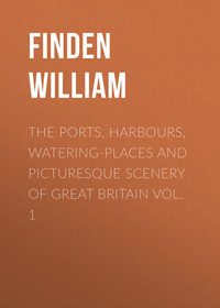
CASTLE OF HOLY ISLAND, AND LINDISFARN ABBEY
In the present engraving the view is taken from the eastward on entering the harbour. To the right is the castle; beyond which, towards the centre of the view, are seen the ruins of the abbey. The setting sun sheds a warm, yet mellow light, over land and sea; and as evening is approaching, and the breeze freshening with the flood tide – for it is evident from the inward swell that the tide is flowing – the fishermen are seen making for the shore. The boats bound merrily before the wind, and
" – the waves, that murmur in their glee,
All hurrying in a joyful band,
Come dancing from the sea."
The painter when he made his sketch must have thoroughly felt the beauty of the scene, and been touched with the influence of the hour: —
"O Hesperus, thou bringest all good things!"
and inspirest poets to sing, and artists to paint the charms of eve's sweet hour in words and colours that never die – for once felt and communicated, they become impressed on the heart and soul of man, and live and bloom there for ever.
Holy Island, which is about two miles and a half long, and about two miles broad, lies off the Northumberland coast. On the south it is separated from the mainland by a deep channel about a mile broad. To the north-west it is connected with the mainland by a sand, which is dry at low water, and by which carts and passengers can pass to and from the island. Speed says that the Britons named it "Inis Medicante, for that, in manner of an island, it twice every day suffreth an extraordinarie inundation and overflowing of the ocean, which, returning unto her watery habitation, twice likewise makes it continent to the land, and laies the shoare bare againe, as before." It was called Lindisfarn by the Saxons; and in after times, from the celebrity of its monastery, and the holy men who had lived there, it acquired the name of Holy Island.
About 635, a church, of wood and thatched with reeds, was first built in Lindisfarn, by Aidan, a Scottish monk from the Isle of Iona, who exercised the office of bishop in Northumberland. It was afterwards built of stone, and gave title to a bishop, until the see was removed to Durham in 995. The monastery continued as a cell, dependent on Durham, till it was suppressed by Henry VIII. A considerable part of the old church, with circular arches in what is termed the Saxon style, is yet standing, and forms, with the adjacent ruins, a most picturesque object. The village, or as it is usually called "the town," lies at a short distance to the northward of the ruins of the monastery, and is chiefly inhabited by fishermen, about two-thirds of whom are also licensed by the Trinity-house at Newcastle to act as pilots for their own harbour and the adjacent coast.
The fishery for cod, ling, and haddock is usually carried on in cobles. These boats are very generally employed in the coast fishery from the Tweed to the Humber. They are sharp and wedge-shaped at the bow, but flat-bottomed towards the stern. They have only one mast, stepped close forward, on which a lug sail is set. They are excellent sea boats, and, for their size, carry a large sail. The usual length of a Holy Island coble is from twenty-five to twenty-seven feet, of which there are about sixty belonging to the island. A great quantity of the fish thus caught is sent to London in smacks, employed by fishmongers or salesmen there, who annually contract with the fishermen to pay them so much per score for all the fish sent during the season. From December to April many lobsters are caught off Holy Island, nearly the whole of which are sent to London.
For the herring-fishery, boats of a larger size are employed. They are from thirty to thirty-six feet long, about eleven feet broad, and from four and a half to five feet deep. They carry two lug sails, and have no deck. The herring-fishery commences off Holy Island about the 20th of July, and usually terminates early in September. Many herrings are caught in the Fare-way, between the Farn islands and the main-land; but the principal fishery for them is generally a little to the southward of the Staples, a cluster of small islands which lie from two to three miles to the eastward of the Farns. Most of the herrings caught by the Holy Island fishermen are taken to Berwick to be cured, and are thence chiefly exported to London, Hull, and Newcastle.
On the beach to the westward of the island, the fossils called St. Cuthbert's beads – the entrochi of naturalists – are found. They are also to be observed in the cliff to the north-east. A rock which lies at a short distance from the south-west point of the island is called St. Cuthbert's rock, where in former times superstition feigned that the saint was wont to sit and
" – frame
The sea-born beads that bear his name."
This article of popular credulity has, however, been long exploded, and the fisherman when he hears the stones rattle on the beach from the force of the waves, no longer imagines that the sound proceeds from the saint's hammer.
CASTLE OF HOLY ISLAND. FROM THE WESTWARD
The Castle of Holy Island stands on a steep rock, about half a mile to the eastward of the Abbey. It is wholly inaccessible, except by a winding pass cut through the rock on the south side. The date of its foundation is unknown; but it is supposed to have been first built by the monks, as a place of refuge against the piratical attacks of the Danes, who frequently annoyed them, and twice burnt their abbey. The most memorable event in the meagre history of this castle is its capture for the Pretender, by two men, Launcelot Errington, and his nephew Mark, in 1715. The garrison at that time consisted of a sergeant, a corporal, and ten or twelve men. Errington, who was master of a little vessel then lying in the harbour, invited the sergeant, and such of his men as were not on duty, to drink with him on board of his ship. The invitation being accepted, he plied them so well with brandy as to render them incapable of opposition. Framing an excuse for going ashore, he proceeded to the castle with his nephew, and succeeded in turning out the old gunner, the corporal, and two soldiers, being all that were on duty. He then shut the gates, and hoisted the Pretender's colours, but being disappointed in the succour which he expected, and a party of the king's troops arriving from Berwick, he and his nephew made their escape over the castle walls, and endeavoured to conceal themselves among the rocks and sea-weed, to the south-eastward of the castle till it was dark, when they intended to swim to the mainland. In consequence of the rising of the tide, they were obliged to swim while it was yet light, and, being perceived by the soldiers, they were taken, and conveyed to Berwick gaol, from which, however, they broke out before they were brought to trial, and escaped to France. On the suppression of the rebellion they took the benefit of the general pardon, and returned to England.
Holy Island is of an irregular form. Its greatest length, including a low sandy point, which stretches out towards the west-north-west, is about two and a half miles. Its mean breadth does not exceed a mile and a half.
Holy Island harbour is a small bay or haven on the south side of the island, between the castle and the ruins of the monastery. On the bar, which is about a mile distant from the town, there is about nine feet at low water at spring-tides. The flood then sets with a strong current in the channel between the island and the mainland; and at high-water there is twenty-four feet on the bar. There is no lighthouse on Holy Island, but there is a beacon on the "Heugh" – a hill between the town and the harbour – on which, in bad weather, when pilots cannot get off, a flag is hoisted during the time of tide that ships may safely enter. In gales of wind from the eastward, coasting vessels sometimes seek shelter in Holy Island harbour, and find good anchorage before the town in three fathoms at low-water.
The Staples and Farn islands, with the rocks and shoals between them and Holy Island, render the in-shore navigation of the coast of Northumberland, from North Sunderland point to the mouth of the Tweed, extremely intricate and hazardous; and the corporation of the Trinity House, London, caution all masters of ships, and especially strangers to the coast, not to attempt sailing within those islands and shoals; more particularly on account of the various settings of the rapid tide which runs in the different sounds between the islands.
A visit to the Farn and Staple islands, from Bambrough or Holy Island, forms a pleasant excursion in fine weather, more especially when the eider ducks are sitting, which is from about the middle of May to the latter end of July. These birds, which are seldom seen, and do not breed to the southward of the Farn islands, are also known in the neighbourhood by the name of St. Cuthbert's ducks. Their eggs, and the fine down with which they line their nests, are collected and sold by the person who rents the islands, which are also the haunt of several other species of water-fowl, such as the sheldrake, the cormorant, and the shag, with auks, guillemots, terns, and gulls. Solan geese also visit the Farn islands, but do not breed there, commonly making their appearance early in spring, and departing before May.
BERWICK. FROM THE SOUTH-EAST
The view of Berwick from the south-east is taken from the Tweedmouth shore, at low-water, about a quarter of a mile below the bridge. In the foreground is a group of salmon-fishers on the shore examining the produce of their last haul, while two others in a coble are shooting the net. To the left are seen the chapel and some of the houses of Tweedmouth; to the right a few ships are perceived lying on the shore near Berwick quay, where the smacks usually take in, and discharge, their cargoes. The spire which towers above the houses, like the steeple of a church, is that of the town-hall. As Berwick church, which stands towards the north side of the town, is without a steeple, it would seem that the inhabitants had determined to make amends for the deficiency by giving their town-hall a steeple like a church.
The town of Berwick stands on the north side of the Tweed, by which it is separated from the county of Northumberland, and about half a mile from the mouth of that river. It is 336 miles north by west from London, and 54 south by east from Edinburgh. As a great part of the town is built on a declivity, which slopes down towards the river, and as most of the houses are covered with red tiles, the view that is first obtained of it, in approaching from the south, on a clear bright day, is very striking, though not very grand. It is almost the only town on the Scottish side of the Tweed in which the houses are so covered; in all the others the houses being, for the most part, roofed with slate.
Chalmers, in his Caledonia, vol. ii, p. 217, speaking of Berwick, says, "this place, lying at the mouth of the Tweed, on a dubious frontier, has an origin obscure, undignified, and recent." That its origin, like the origin of most other towns in Great Britain, is obscure, may be admitted; but the term "recent" can scarcely be applied with propriety to a town which was of such consequence in the reign of David I. as to be appointed one of the "Four Boroughs,"10 which, by their Commissioners, met annually at Haddington, where, under the presidency of the King's Chamberlain, they formed a Court of Appeal from the jurisdiction of other boroughs, and exercised an authority in commercial affairs. As nothing is positively known respecting the origin of Berwick, it is impossible that an uninspired antiquary should be able to decide whether it was "undignified" or not. Its first "kirk and mill" – the primary conditions of a town – were more likely to be founded by a noble than by a serf.
In 1174, Berwick, with the castles of Jedburgh, Roxburgh, Stirling, and Edinburgh, was delivered up to Henry II. as security for payment of the ransom of William the Lion, King of Scotland, who had been taken prisoner when besieging Alnwick; and it remained in the possession of England until 1189, when Richard I. restored it with the other castles to William for the sum of 10,000 marks. In 1216, Berwick was plundered and burnt by King John, but in a short time was rebuilt by the Scots, in whose uninterrupted possession it continued until 1296, when it was taken by Edward I. at the commencement of the Scottish war of independence, which was first waged by Wallace, and afterwards by Bruce, against Edward and his successor; who, laying claim to the sovereignty of Scotland, endeavoured to reduce that country to a state of vassalage, and to compel her kings to do homage to England for their crown. From this war may be dated that jealous and hostile feeling with which the two countries continued to regard each other for nearly three centuries afterwards, and was only modified in the reign of Elizabeth – when there was a prospect of a Scottish king succeeding to the English throne, and when open warfare was succeeded by political intrigue – but which was not wholly extinct at the Union of the two kingdoms in 1707.
In 1484, it was agreed on, by commissioners appointed by the two kingdoms, that the debatable ground in the neighbourhood of Berwick should remain without culture, buildings, or inhabitants; and by a treaty, concluded at Norham, 10th June, 1551, between Edward VI. and Mary Queen of Scots, Berwick was declared to be a free town, independent of both kingdoms. Notwithstanding this declaration, Berwick continued subject to English authority, and, during the reigns of Mary and Elizabeth, was garrisoned with English soldiers. At the Union of the two kingdoms in 1707, Berwick, as a salvo to national pride, was considered as a separate and independent territory; and it is to this cause that, in Public Acts and Forms of Prayer, the "Town of Berwick-upon-Tweed" is especially mentioned.
LEITH
This view is taken from the pier, with Edinburgh, the Castle, the Calton-hill, Salisbury-crags, and Arthur's-seat in the background.
Leith, which performs nearly the same important services to the "Modern Athens" as the "Piræus" did to the Ancient, has long served as the port and harbour of Edinburgh, to the prosperity of which, as well as to that of the whole country, it has greatly contributed. As early as the beginning of the fourteenth century the citizens of Edinburgh received from King Robert I. a grant of the harbour of Leith; but, owing to the resistance of a powerful family, to whose interests it was prejudicial, the royal grant was of little or no value to the city. As soon, however, as the difference was adjusted, and the corporation of Edinburgh had obtained undisturbed possession of the harbour, symptoms of mercantile prosperity became visible. But as this prosperity was confined to the corporation, the inhabitants of Leith were naturally incensed at the monopoly; they felt themselves debarred from the natural advantages, profits, and employments of their maritime position, and daily beheld the wealth which flowed into their port transferred to the hands of those who were neither resident nor proprietors in the place. In 1555 a strong effort was made by the inhabitants of Leith to throw off their humiliating dependence. With this object in view they petitioned the Queen Regent of Scotland, Mary of Lorraine, for the royal sanction and assistance; and succeeded as far as to get Leith erected into a burgh of barony, a preparatory step to its being raised to the independence of a burgh royal. From this epoch, however, having obtained letters patent, empowering the inhabitants to elect magistrates, and charters for erecting divers of their trades and arts into corporations, Leith acquired the name and distinction of a town. By these charters the people were divided into four classes, each of which became an incorporated body, known as the shipmasters, the traffickers or merchants, the maltmen, and the trades' companions; the last of which possesses exclusive privileges.
The port and harbour of Leith have always been an object of paramount interest to the country at large, and, from time to time, various plans for their improvement and extension have been carried into effect. There are now two dry-docks for building and repairing vessels – a branch of the craft which is here brought into extensive operation – and two wet-docks, each three hundred feet wide by upwards of seven hundred feet long, and occupying, with their appurtenances, a space of about three hundred acres. On these important works upwards of two hundred and fifty thousand pounds have been expended. The basins are enclosed by well-constructed quays and capacious warehouses for the reception of merchandise. The Custom-house, the Exchange, the Trinity-house, the Bank, the Court-house, the Baths, the Grammar-school, &c., are all elegant buildings, designed with classic taste, and of modern erection.
Leith enjoys an extensive commerce with the Baltic, the northern parts of Europe, Holland, France, Spain, Portugal, the Mediterranean, North America, and the West Indies; besides a widely ramified coasting-trade, and a share in the whale and herring-fisheries. The Leith smacks have been famous for their safety and swift-sailing properties; and the powerful steam-ships, which now maintain an almost daily intercourse with London, are proverbial for their speed and accommodation.
The growing prosperity of Leith is fully evinced by the number of trading vessels in its port, the mercantile business carried on in every street, the crowded warehouses and ships, its rope-works, canvas manufactories, sugar-refining-houses, breweries, distilleries, soap-works, iron-foundries, glass-works, and other establishments of local industry. But the tide of prosperity, it is said, is prevented from reaching its height by the corporation of Edinburgh, who, by increasing the rate and number of the port-dues of Leith, have caused various branches of commerce to seek encouragement in Kirkcaldy, Dundee, Aberdeen, and other places.
The depth of water in the harbour of Leith is stated at only sixteen feet at spring-tides, and ten feet at neap-tides; so that very large vessels cannot enter the port; but at a mile from the mouth of the harbour there is excellent anchorage in what is called Leith Roads. The fort, garrisoned by the royal artillery, is a place of great strength.
The municipal government of Leith is vested in a provost, four baillies, a treasurer, and ten common-councillors, and, in connexion with Portobello and Musselburgh, returns one member to Parliament.