Kitabı oku: «The Ports, Harbours, Watering-places and Picturesque Scenery of Great Britain Vol. 1», sayfa 2
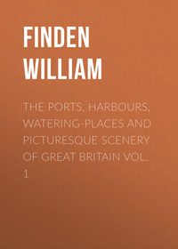
YARMOUTH, WITH NELSON'S PILLAR, (FROM THE LOWESTOFT ROAD)
"A fertile soil, a fruitful sea,
And wealth amassed by Industry;
And patriot virtues that sustain
Their 'Meteor-flag' on land and main;
A scene where Nelson's gallant name
Is 'watch-word' to immortal fame:
And here, – with grateful triumph crown'd, —
Imparts a charm to all around."
Yarmouth Pillar.
Yarmouth, as a market-town and sea-port, enjoys many natural advantages; and, aided by the public spirit of its inhabitants and a train of successful enterprise, has long enjoyed a well-merited distinction in the chart of the British Empire. It is a borough, both corporate and parliamentary, situated at the eastern extremity of the county, near the mouth of the river Yare, from which it derives its name, and which is navigable as far as Norwich. Joined by its tributaries, the Waveney and Bure, a short distance to the west of the town, in a fine sheet of water called the Breydon, it proceeds in a copious stream to the sea. The Waveney and the Bure are both navigable rivers – the former as far as Bungay, and the latter to Aylsham.
The town, extending upwards of a mile along the river, from north to south, occupies an area of at least a hundred and thirty acres. On the western side it is bounded by the river, over which there is a handsome drawbridge, communicating with South Town or Little Yarmouth, one of its populous suburbs, where extensive business is carried on. The principal streets, running north and south – Regent-street and South-street excepted – are all indicative of the stir and animation which pervade every place of trade, and evince in their construction both taste and comfort, with an occasional air of the picturesque. The market-place of Yarmouth is extensive, covering an area of nearly three acres, and inclosed on the west side with a range of handsome and well-furnished shops.
Among the public edifices of Yarmouth, which merit especial notice, is the Town Hall, which stands near the centre of the quay. It is an elegant modern structure, with a portico admirably proportioned, and supported by pillars of the Tuscan order. The interior consists of a noble room, finely designed and ornamented, with a richly embossed ceiling in stucco, from which are suspended three massive and superbly cut lustres, containing seventy-six lights, which are used on festive nights, when, with permission from the mayor, public assemblies are held within its walls. Over the chimney-piece is a full-length portrait of George III., in which is preserved a faithful resemblance of that sovereign. The theatre, erected about sixty years ago, and the bathing-establishment, with a spacious public room adjoining, where the company are supplied with refreshments, are among the other places of public resort. A jetty, twenty-four feet wide, secured by a strong railing, and extending four hundred and fifty-six feet into the sea, on piles of wood, forms a delightful promenade, where health of body and exhilaration of mind may be greatly promoted by the salubrious sea breezes by which it is constantly visited. Near this, and commanding a magnificent view over the German Ocean, the stranger is particularly struck with the appearance of a marine villa, which harmonises admirably with the scene.
At a short distance from the pier is a noble pile of buildings, belonging to the barrack department and erected on a portion of the South Denes. In the centre of the latter rises the triumphal Pillar, which forms so striking a feature in the landscape, and awakens so many proud and heroic associations in the heart of the spectator. This monument, raised to commemorate in his native county the services of the immortal Nelson, is worthy of the virtue and valour it was designed to celebrate. It was erected in 1817, by W. Wilkins, Esq. Both in the design and execution great solicitude was evinced by the public that a monument, bearing the name of the greatest of our Naval Heroes, should present everything that classical taste and national gratitude could suggest – and in this respect his countrymen have been fully gratified. It is of the Doric order, fluted and ornamented with appropriate decorations and title-inscriptions – illustrating the Hero's most celebrated battles – and surmounted with a ball and an exquisitely cast figure of Britannia, supporting her trident and laurel wreath. The ascent is by an easy flight of two hundred and seventeen steps, and the whole is built of white Scottish marble. Its height from the ground is one hundred and forty-four feet; the diameter of the column or shaft is twelve feet six inches; and the pedestal is twenty-three feet square by twenty-seven feet in height.
CROMER
Cromer is a fishing village, situated near the north-eastern extremity of the county of Norfolk. It lies about 129 miles north-north-east of London, and about 22 miles nearly due north of Norwich. The view in the engraving is taken from the sands, looking to the westward. Some years ago, part of the cliff, with two or three houses beyond those which are now seen standing on its extremity, fell down in consequence of the encroachments of the sea. At that time a subscription was entered into by the inhabitants of the place, and by several of the neighbouring gentry, for the purpose of forming a breakwater; for without some such protection it was apprehended that at no very distant period many more houses, with the fine old church, would fall a prey to the violence of the sea.
It is supposed that Cromer was formerly a place of much greater importance than it is at present; and that at the time of the Domesday survey it was included in the town of Shipden, which, with its church, is supposed to have been destroyed by the sea in the reign of Henry IV. At low water many large portions of wall are to be seen, which have evidently formed part of the houses of the old town of Shipden. "The set of the great tidal current of the German Ocean," says Mr. R. C. Taylor, in his Geology of East Norfolk, "is from the north-west, along the eastern shores of this island. In their progress southward, the tides meet with an extensive obstruction in the projecting county of Norfolk. About twenty miles of its coast has been subjected, from time immemorial, to the abrasive action of ocean currents. The ancient villages of Shipden, Wimpwell, and Eccles, have disappeared; several manors, and large portions of neighbouring parishes, have, piece after piece, been swallowed up by the encroaching waves; and their site, some fathoms deep, now forms a part of the bed of the German Ocean."
The sea in this neighbourhood, and on the whole of the Norfolk coast, is particularly dangerous. Between Flamborough and Spurn Heads, and Winterton Ness, the most easterly points of land on this side of the island (excepting the North Foreland), the land retreats inward, forming a large bay. If vessels leaving Flamborough Head proceed southward and meet with a hard gale from any point between north-east and south-east, or of leaving Yarmouth Roads, proceeding northwards, they are retarded by the wind blowing hard from the north-east; so that as they cannot weather Winterton Ness, they become embayed, and the only chance of safety is to run for Lynn Deeps, in attempting which they are in danger of foundering on the rocks near this town or stranding upon the flat shores between Cromer and Wells.
Cromer is much frequented in summer by visitors for the sake of sea-bathing, for which the fine sandy beach to the eastward affords great convenience. It is a place of very little trade, and is chiefly dependent on the fishery. Cromer light-house stands on an eminence, about three-quarters of a mile to the eastward of the village. It is a revolving light, and is visible, in clear weather, at a distance of five or six leagues. It appears in its brightest state once in every minute, and then gradually becomes eclipsed.
KINGSTON-ON-HULL
Hull, though one of the most considerable ports of the kingdom, is also one of the least picturesque. From its low situation, little more of the town can be seen than the modern houses near the banks of the Humber; and though jetties, dock-gates, and pier-heads, are sometimes useful as accessories in a picture, yet where such occupy almost the entire line of the foreground, with a row of brick buildings behind them, the painter must manage his subject as he best can, and be content with giving correctly that which his art cannot improve: – "Res ipsa negat ornari." The view of Hull, from a painting by Balmer, is taken from the Humber, looking towards the north. Beyond the river-craft, which are seen in front, is the entrance to the Humber dock; and the jetty to the right, which appears crowded with people, is a favourite promenade with the inhabitants of Hull, who sometimes assemble there in crowds to watch the sailing and arrival of the steam-packets. The most distant building to the right is the citadel, at the entrance of the river Hull, which then discharges itself into the Humber. Towards the middle of the engraving is seen the tower of Trinity Church, the only object which, at the distance of a mile, commands the attention of the stranger, and gives an individual character to the river.
The town of Hull, or, as it is sometimes called, Kingston-upon-Hull, is in the East Riding of Yorkshire, and lies about one hundred and seventy miles northward of London, and about thirty-nine to the south-east of York. On the south it is bounded by the Humber, and on the eastward by the small river Hull. The old town, which was formerly protected on the north and west by a wall running from the Hull to the Humber, is now wholly insular, as a line of wet-docks occupies the site of the old fortifications. The suburbs, of Sculcoates on the north, and Drypool on the east, may be considered as forming, with the old borough of Hull, but one large town.
The Hull, which is but a small river, has its source near the village of Lissett, about five miles from Burlington, and after running about twenty-six miles, in a southern direction, discharges itself into the Humber, on the east side of the town to which it gives name. It is navigable for small craft as far as Elmotlands about sixteen miles from its mouth. It contains many fish, such as roach, perch gudgeon, eels, and pike; and Driffield Beck, one of its tributaries, is famed for the size and excellence of its trout.
The Humber, which opposite to Hull, is nearly three miles broad, and about six fathoms deep in mid-channel, is formed by the junction of the Trent and the Ouse, about sixteen miles above Hull, and it discharges itself into the sea about twenty-four miles below that town. From the rapidity of the current, which at spring tides runs at the rate of five miles an hour, and from the numerous sand-banks which are in the river, the navigation of the Humber is both intricate and dangerous; for should a vessel get aground on one of the sands, she is extremely liable to be overset by the force of the tide. Such accidents are, indeed, by no means uncommon, for almost every year affords instances of vessels, both ships and river-craft, being lost in the Humber in this manner. In the upper part of the Humber, in the Trent, and in the Ouse between Trent-falls and Selby, the flood tide, more especially in a strong easterly wind, frequently rushes up the river like a wave, considerably raised above the water which it meets. This tidal wave is called by the people of Hull and its vicinity the "Ager," – the g being pronounced hard; and from the murmuring sound which it makes, as it rolls onward and dashes against the shore, it has been supposed that the river was called the "Humber." Drayton, in his Poly-Olbion, thus notices the "Ager," or as he spells it, the "Higre," in his description of the Humber: —
"For when my Higre comes, I make my either shore
Ever tremble with the sound that I afarre doe send."
Taylor, the water-poet, observed this tidal wave in the estuary of the Wash below Boston: —
"It hath lesse mercy than beare, wolfe, or tyger,
And, in those countries it is called the Hyger."
Dryden, who had noticed it in the river Trent, calls it the "Eagre."
"But like an Eagre rode in triumph o'er the tide."
BURLINGTON QUAY
The Engraving of Burlington Quay, from a painting by Balmer, presents a view of the entrance to the Harbour from the eastward. To the right is seen the inner part of the Old Pier, as it appeared after the great storm of 17th and 18th February, 1836. In front are the houses at the end of Quay Street, and to the left is the South Pier; between this and the shore two ships are perceived aground at the entrance of the inner harbour, which is nearly dry at low water. In the storm above alluded to, great injury was done to the old North Pier, and part of one of the houses to the right was washed down by the violence of the sea.
Burlington Quay lies about a mile to the north-east of the market-town of Burlington, and at the bottom of a bay of the same name. It is in the East Riding of Yorkshire, and is about two hundred and eight miles from London, forty from York, and twenty from Scarborough. The earliest mention of it as a harbour occurs in a mandate of King Stephen, addressed to the Sheriff of Yorkshire, commanding him to allow the Prior of Burlington to hold it on the same terms as Walter de Gaunt, and Gilbert, his ancestor, had held the same. During the time that it was in the possession of the Priors of Burlington, it seems to have been an inconsiderable place; but subsequently, as the coal trade between London and the northern parts of the kingdom increased, it began to be of greater importance as a harbour, in consequence of its affording shelter in stormy weather to vessels engaged in that trade. In 1546, an act was passed imposing a duty for erecting the piers and keeping them in repair; and, in 1614, a second act was passed, upon a petition from the merchants and ship-owners of the eastern coast, imposing a duty, for the same purposes, on all coals shipped at Newcastle. Since 1614, several other acts have been obtained, authorising the levy of duties and tolls for the purpose of improving the harbour and repairing the piers; and since 1816, the sum thus collected has averaged about £1,750 per annum.
The harbour at Burlington Quay is almost entirely the work of art, as the small stream which there runs into the sea is scarcely sufficient to turn a mill. Its locality seems to render it one of the most appropriate stations for a harbour of refuge between the Frith of Forth and Yarmouth Roads, more especially in gales of wind from the north-eastward; but unfortunately it can only be entered by comparatively small vessels, as the depth of water at the entrance is only from ten to twelve feet at neap-tides, and from fourteen to sixteen feet at springs. The harbour is also so small, that fifty sail of colliers taking shelter there would render it extremely crowded.
The history of Burlington Quay, considering it as a separate place from the town of Burlington, is extremely meagre. The most remarkable event which its annals record is the landing there of Henrietta Maria, Queen of Charles I., on her return, in 1643, from Holland, whither she had been to conduct her newly-married daughter to her husband, the Prince of Orange, and where she pledged part of the crown jewels in order to obtain money to purchase arms for the Royalists. The Queen, who was attended by a convoy of Dutch men-of-war, under the command of Admiral Van Tromp, landed at Burlington Quay, on the 22nd of February. The Parliamentary admiral, Batten, who had been cruising, with four ships, for the purpose of intercepting her, having received intelligence of her arrival, sailed into the bay and began to cannonade the town. Several of the shot struck the house in which the Queen was lodged, so that she was obliged to leave it, and take shelter in a ditch in a neighbouring field. A serjeant was killed near her, and the Parliamentary admiral continued his fire until the reflux of the tide and the threats of Van Tromp compelled him to desist.
Burlington Quay is much frequented in summer as a bathing-place; and many persons prefer its quiet and retirement to the greater gaiety of Scarborough. The beach, to the northward of the quay, affords excellent opportunities for bathing, and the walks and rides in the vicinity are extremely pleasant. A visit to Flamborough Head, which is only about five miles distant, forms a highly interesting excursion either by land or water.
The market-town of Burlington, or, as it is frequently spelled, Bridlington, is situated about a mile to the north-westward of the quay.
FLAMBOROUGH HEAD
The view of Flamborough Head, drawn by Balmer, is taken from the cliffs to the north-west. To the left is the promontory properly called "The Head," at a short distance from which stands the lighthouse. Between the Head and the nearer cliffs is a small haven, which is used as a landing place by the fishermen of the village of Flamborough, which lies about a mile to the south-west of the lighthouse.
Flamborough Head, which lies about eighteen miles southward of Scarborough, and four and a half miles northward of Burlington, is one of the most remarkable promontories on the eastern coast. It projects about five miles into the sea, from a line drawn between Burlington Quay and Filey; and its southern side forms the northern boundary of Burlington Bay. The cliffs, which are of limestone rock, are from three hundred to four hundred feet high, and their crumbling sides form the haunt and the breeding place of innumerable flocks of sea-birds: among which are cormorants, puffins, razor-bills, and guillemots, with gulls and terns of several species. Guillemots, which are here extremely numerous, are known to the seamen of Shields and Newcastle by the name of "Flamborough-head pilots," as their presence in considerable numbers is almost a certain indication of the ship being "off the Head." Great numbers of those feathered denizens of the cliff are killed every year by "parties of pleasure," from Burlington, Scarborough, and other places, who visit the "Head" for the sake of indulging in the heartless sport, which requires neither skill nor courage, of killing birds by wholesale. At the foot of the cliff, which to the north-west is much indented, there are several caverns and large insulated masses of rock. The largest of those caverns, called Robert Lyth's Hole, has two openings, the one communicating with the land and the other exposed to the sea. The roof, though low at the landward entrance, is in some places fifty feet high; and the view, looking through the rocky vault towards the sea, is extremely grand.
Flamborough Head, which is a most important land-mark for vessels navigating the eastern coast, lies in 54° 8' north latitude; longitude 2' 30" west. A revolving light is displayed from the lighthouse from sunset to sunrise, and presents, first the appearance of two lights on the same tower, and next a brilliant red light. Each of those lights appears at intervals of two minutes; and after gradually attaining their greatest lustre, they in the same manner decline and become eclipsed.
Between Flamborough Head and Burlington Quay, is situated Burlington Bay, a secure roadstead in north-east gales; and, during the prevalence of such winds, it is not unusual for three hundred ships to be riding there at the same time, sheltered from the violence of the wind and sea by the lofty promontory. On the south-east, the Bay is partially sheltered from the violence of the sea by the Smithwick Sands, which run nearly in a line with the coast, from Burlington Quay to Flamborough Head. At each extremity of those sands there is a channel leading into the Bay; that towards the Head is called the North Sea; and the other, towards Burlington, the South Sea. Though the Smithwick Sands effectually break the violence of the sea at low water, yet at high water, when they are covered to a considerable depth, the protection which they afford, in gales of wind from the south-eastward, is not to be depended on. Vessels, therefore, leave the Bay as soon as the wind changes to east or south-east, as it no longer affords them sufficient security; the protection of the Smithwick Sands not being equivalent to the risk of the lee-shore, to which they would be exposed in a gale from the south-east. Were the harbour of Burlington, which is situated to the westward of the Bay, enlarged and deepened, its importance, as a place of refuge for vessels compelled to leave the Bay from the wind changing to the eastward, would be very greatly increased. Could it be so enlarged as to admit one hundred vessels, of from 200 to 300 tons each, it would, with the Bay, afford a place of refuge in all storms from north-east to south-east, which are generally the most destructive on the eastern coast.