Kitabı oku: «The Ports, Harbours, Watering-places and Picturesque Scenery of Great Britain Vol. 1», sayfa 3
SCARBOROUGH
In this view of Scarborough, by Harding, which is taken from the southward, the most conspicuous object is the Lighthouse on the Old Pier, or, as it is sometimes called, Vincent's Pier, from the name of the engineer, by whom the outer portion was erected about the year 1750. Beyond the pier are seen the masts of vessels lying in the harbour; to the left are the houses, which are built near the shore between West Sand-gate and Bland's Cliff; and on the height are the barracks, with the ruins of the old castle, a little further distant, to the left.
Though the name of Scarborough appears to be of Saxon origin, yet as the place is not mentioned in any author who wrote before the Conquest, nor in the Domesday-book, we cannot reasonably suppose it to have been of much importance, either during the Saxon period, or at the time when the Conqueror's survey was made. The castle of Scarborough was built about 1163, by William le Gros, Earl of Albemarle and Holderness; and from that period the authentic history of the town commences. The castle is situated to the north-eastward of the town, and is built on the isthmus of a peninsula, which comprises an area of about sixteen acres, and is bounded on the north, east, and south by inaccessible cliffs, whose summits are about 300 feet above the level of the sea. The western boundary, overlooking the town, is also formed by an elevated rock; and the only means of approach to the castle is by a steep path near the edge of the cliff forming the north side of the isthmus. On passing through a gateway, and over a draw-bridge, we arrive at the castle, which, previous to the introduction of cannon, must have been almost impregnable. The keep or principal tower is ninety-seven feet high, and though greatly dilapidated, is yet a striking object, more especially when viewed from the sea, at about two miles' distance from the north cliff.
There is no river at Scarborough; and the harbour, which is formed by the piers, is only accessible towards high water. It is high water at Scarborough at forty-five minutes past three o'clock at the full and change of the moon; and at spring tides there is about twenty-two feet water at the end of the pier. At night a light is shown from the lighthouse as long as there is twelve feet water at the entrance to the harbour; and during the same period a flag is hoisted by day.
About 1620 the sanative virtues of the Spa-well were discovered by Mrs. Anne Farrow, who "sometimes walked along the shore, and observing the stones over which the water passed to have received a russet colour, and finding it to have an acid taste different from the common springs, and to receive a purple tincture from galls, thought it probably might have a medical property." The lady having tried the water herself, and persuaded others to do the same, it was in a short time pronounced an all-heal, and the people of the place took it as their usual physic. Before 1670 these waters had become celebrated, and many persons resorted to Scarborough for the sake of drinking them. Medical men, however, disagreed both as to their composition and effects; and the opinions of Dr. Witty, a resident physician, who recommended them in every case, were controverted by Mr. Simpson and Dr. George Tonstall. The latter says of the Spa-water, "The essence is fit for the cup of a prince; the caput mortuum, which is sand and clay, is fit for nothing but the bricklayer's trowel. Hence it doth follow that those who are weak in their digestive faculties, and strong in their distributive, may find good by drinking this water; but those who are weak in both will experience the contrary." From the following anecdote related by the doctor, we may infer that the spa-drinkers of that period were accustomed to indulge in rather copious draughts. "Mr. Westro came to us at Scarborough only to visit his friends, and the two or three days he drank the waters (not above two quarts at a time), did so far put him out of tune, that he made his complaint to me he could neither eat nor sleep; and it took me a week's time before I could reduce him to the state of health which he had before he meddled with the waters." He would have been a person of strong constitution indeed not to have been "put out of tune" by such drenching; and it is no small proof of Dr. Tonstall's skill that he should have been able to restore Mr. Westro the blessings of sound sleep and a good appetite in so short a time as a week. From the double advantage which Scarborough presents to visitors, of drinking the waters and enjoying the benefit of sea bathing, it is much frequented during the summer season; and a more agreeable place is not to be found on the coast betwixt the Humber and the Tyne.
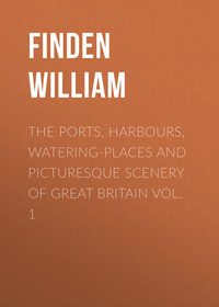
WHITBY
This engraving of Whitby, from a drawing by Harding, presents a view of the entrance to the harbour, as seen from the northward. Towards the middle of the plate is seen the end of the east pier; on the top of the cliff are the ruins of the abbey and the parish church; while, farther to the right, part of the town is perceived.
Whitby is in the North Riding of Yorkshire, and lies about 246 miles north of London, 22 north-north-west of Scarborough, and 47 north-east of York. It is chiefly built on the sloping banks of the river Esk, by which it is divided into two parts; that on the west side being the most populous. The opposite parts of the town are connected by means of a bridge, the middle of which is moveable for the purpose of allowing ships to pass through. In the old bridge, which has been pulled down, the opening in the middle was upon the principle of a drawbridge, in which the roadway is raised and lowered by means of beams and chains. At high-water the river above the bridge expands into a spacious harbour, where ships can lie in perfect security; but at ebb tide, except in the mid-channel, the harbour is nearly dry. In the outer harbour, as it is called, below the bridge, vessels cannot ride with safety in gales of wind upon the land.
The piers at the entrance to Whitby harbour are not built and maintained at the sole expense of the place, but by a duty on coals shipped at Newcastle, Sunderland, Blyth, and their dependencies – Yarmouth vessels only being exempt – and the sum thus raised amounts to upwards of £2,000 per annum. It is doubtless a great advantage to the people of Whitby to have their piers built and kept in repair at the expense of other ports; but it is equally certain that the same sum might be employed more to the advantage of those by whom it is paid in improving other places – Scarborough and Burlington, for instance – as harbours of refuge on the eastern coast. In a gale of wind from the eastward, Whitby is perhaps one of the most dangerous harbours that a vessel can attempt to take between Yarmouth roads and the Frith of Forth, and captains of coasting vessels cannot be too frequently warned to avoid it. As the flood tide sets strong to the southward across the entrance to the harbour, vessels in attempting to enter with a gale of wind from the north-east are extremely liable to be driven on the rocks and wrecked at the foot of the cliff beyond the east pier.
A singular customary duty, called "making the penny-stake hedge," is annually performed at Whitby, by certain tenants of the Lord of the Manor. It consists in driving a certain number of stakes, which, according to the ancient prescribed form, were to be cut with a knife of the value of one penny, on the shore of the south side of the Esk, at low-water mark, at nine o'clock on the morning of the day before Ascension-day, while a man with a horn blows, "Out on you! Out on you!" to the shame of the persons whose duty it is to drive the stakes. When it shall be full sea or high-water at nine o'clock on the day of performing this service, it was to cease; but as Ascension-day is regulated by the change of the moon this can never happen. This custom is of great antiquity, as the horngarth, the enclosure formed by the stakes, is mentioned about 1315 in the registers of the Abbey, in an account of certain disputes between the abbot, Thomas de Malton, and Alexander de Percy, of Sneaton. Tradition reports that this custom was imposed as a penance on three persons of the families of Percy, Bruce, and Allatson, who held lands of the Abbey, for having killed a hermit in the chapel of Eskdale-side, when hunting a wild boar which had there taken refuge. The penance imposed was the tenure by which they and their successors were to hold the Abbey lands.
Leland, who visited Whitby a few years before the suppression of the monastery, describes it as a "great fisher town;" and he mentions that when he was there a new quay and pier were in course of erection. Until the establishment of the alum works in its neighbourhood, towards the latter end of the reign of Queen Elizabeth, Whitby appears to have been a place of little trade. As this new branch of commerce extended, the trade and population of Whitby steadily increased until it has attained its present importance.
WHITBY, FROM THE NORTH-WEST
The view of Whitby from the north-west, by Balmer, is taken from the sands near Upgang, between Whitby and the village of Sandsend. From this point nearly the whole of the west pier is seen, extending directly from the shore, and having a light-house near its outer extremity. Beyond the pier, and on the other side of the river, are seen the houses built on the sloping side of the cliff, and on its top the ruins of Whitby abbey, which
"In solemn grandeur, calm and still,
O'erlook the restless flood."
The first authentic notice that we have of Whitby, is contained in Bede's Ecclesiastical History. In the time of the venerable historian it was called in the Anglo-Saxon language Streoneshalh, a name which he interprets in Latin by the words Sinus Fari; that is, in English, "Light-house bay." Subsequently it received from the Danes its present name of Whitby, a word which is probably derived from hvit or whit, white; and by, a dwelling, or in its more extended sense, a village or town. It has been supposed that this name might be given to the village in consequence of its being built chiefly with stone taken from the ruins of the monastic buildings; but the supposition is untenable, unless we at the same time presume that the stones, which were taken from buildings which had been destroyed by fire, were rendered white by being burnt. In Domesday Book the place appears to be called Prestebi– Priestby – as well as Witeby– Whitby. The name Priestby, which soon became obsolete, probably denoted that part of the village which lay on the east side of the Esk, and was more immediately dependent on the monastery.
The abbey of Whitby, founded by St. Hilda in 658, acquired considerable importance as the residence of this saint, of whose miracles certain marvellous traditions are still current in this vicinity. At the dissolution, under Henry VIII., Richard Cholmley, Esq., obtained a lease for twenty-one years of the site of the abbey and several parcels of its lands. In 1550 those lands were sold by the crown to John, earl of Warwick, who again sold them to Sir John Yorke, of whom they were purchased by the original lessee, then Sir Richard Cholmley, in 1555. Since that time the property has continued in the family of Cholmley, who enjoy many valuable rights and privileges as lords of the manor of Whitby. On the dissolution of the monastery, the abbey was stripped of every thing that was valuable. The bells were taken down, and the church was unroofed for the sake of the timber and lead. The walls only were spared, as the cost of taking them down would probably have been greater than the value of the stones. Though time has destroyed much of Whitby Abbey, yet the ruins still form a conspicuous and interesting object when viewed from the sea. The tower, which for several preceding years had been in a tottering state, fell down 25th June, 1830. The parish church, a plain structure, probably founded about the beginning of the twelfth century, stands at a short distance to the north-westward of the abbey. The direct foot-way to the church-yard from the town is by a steep ascent of one hundred and ninety steps.
It is worthy of remark that the number of ships registered at Whitby by no means affords a criterion of the trade of the place, for the greatest part of them are freighted to and from other ports. Perhaps no port in the kingdom presents so great a difference as Whitby between the number of ships registered at the port, and the number annually entered and cleared. This discrepancy between the trade and the tonnage of the port arises from the circumstance of many wealthy persons who live there having their ships built and registered at Whitby, but chiefly employed, on freight, in the trade of other places. When speaking of the shipping of Whitby, it would be unpardonable not to mention that Captain James Cook one of the most distinguished of British circumnavigators, served an apprenticeship in a vessel belonging to that port.
The principal trades carried on at Whitby are ship-building, and the manufacture of sail-cloth. Its chief imports are coals from Newcastle and Sunderland, and timber, hemp, flax, tar, iron, and tallow, from the Baltic. Alum manufactured in the neighbourhood is shipped at Whitby, but the principal article of export is at present stones for building, of which great quantities are sent to London.
From the light-house, on the western pier, a tide-light is displayed at night time, as long as there is eight feet water on the bar. The light is stationary, and is visible at the distance of two leagues in clear weather. During the same period of tide, in the day, a flag is hoisted on the west cliff. It is high water at Whitby pier at forty minutes past three o'clock at the full and change of the moon.
ROBIN HOOD'S BAY
The above is the name of a fine bay on the Yorkshire coast, between Whitby and Scarborough, and also of the fishing village, situated towards its northern extremity. In the view, which is taken from the north, several of the houses are seen standing upon the very edge of the cliff. The promontory to the left is called Ravenhill, and forms the south-eastern extremity of the bay. From an inscription dug up at Ravenhill in 1774, it appears that there had formerly been a Roman camp there.
The ancient name of the bay was Fyling, and from what reason or at what period it first received the name of Robin Hood's Bay is uncertain. That it ever was the resort of the famed outlaw of that name is extremely questionable; although two or three tumuli on the moor, about two miles to the southward of the village, are said to be the butts, in shooting at which he exercised his men in archery. Near Whitby Lathes, about five miles to the north-west of Robin Hood's Bay, are two upright stones, which are said to mark the spots where the arrows of the bold robber of Sherwood Forest, and his man Little John, fell, when, in a trial of strength, they discharged them from the top of Whitby Abbey in the presence of the abbot. As the distance from these stones to the abbey is rather more than a mile and a half, it is evident that a long bow must have been drawn by some one, if not by Robin Hood. It has been supposed that the place was originally called Robin Wood's Bay, from a fisherman of that name, who formerly resided there; but this conjecture rests on no better ground than the fact of two or three fishermen of the name of Wood having lived there in modern times. A family of fishermen of the name of Wood, with whom "Zebedee" appears to have been a favourite "fore-name," have resided at Runswick, a fishing village, about seven miles northward of Whitby, for several generations.
Leland, in his Itinerary, written about three hundred years ago, calls the village by its present name, Robin Hood's Bay, and describes it as "a fisher townlet of twenty boats." It is still, as in his time, almost entirely inhabited by fishermen. The houses forming the principal street are built on each side of a steep road, leading down to the shore; while others, as may be seen in the view, are built upon the very extremity of the cliff. The approach to the village is by a steep descent, which is extremely inconvenient for carriages. It is about fourteen miles north-west of Scarborough, and seven south-east of Whitby; and the population is about a thousand.
Robin Hood's Bay, Filey, Runswick, and Staithes, are the principal fishing villages on the Yorkshire coast. Filey is about eight miles south of Scarborough; Runswick, as has been previously observed, is about seven miles northward of Whitby; and Staithes is about three miles northward of Runswick. At each of those places the fishery is carried on both by cobles and by five-man boats. At most of the other fishing stations on the Yorkshire coast cobles only are employed. A description of the last named species will be found in our notice of Bambrough from the South-east; and of the five-man boats, we propose to say a few words on the present occasion.
The vessels now called five-man boats are about forty-six feet long, sixteen feet eight inches broad, and six feet three inches deep. They are clinker-built, sharp at the bows, and have a deck with a large hatchway in midships, and a cabin towards the stern for the men. They have three masts, on each of which they carry a lug sail. Their other sails are a jib, and, in fine weather, a top-sail set on a shifting topmast, above the main-mast. As the sails are all tanned, a five-man boat forms a picturesque object at sea, more especially when viewed in contrast with a square-rigged vessel with white sails. The crew of each five-man boat consists of seven persons, five of whom, called shares-men have equal shares of the proceeds of the voyage, or the season, after the boat's share is paid. The sixth person is often a young man who receives half a share, and is a kind of apprentice to the captain or owner of the boat. The seventh is generally hired at a certain sum per week, and not sharing in the profits of the fishery.
To each five-man boat there are two cobles, which in proceeding to the fishing ground are generally hauled up on the deck. On arriving at the place where it is intended to fish, the boat is anchored, and the cobles being launched, three men proceed in each to shoot their lines, while one remains on board. The lines used for this more distant fishery are called haavres. They are about the same length as those used in the coble fishery nearer the shore, though thicker, and having the hooks placed at greater intervals. As the six men who fish have each two sets of lines, they are thus enabled to shoot one set immediately after they have hauled the other. In the five-man-boat fishery the hooks are always baited at sea.
HARTLEPOOL
The view of Hartlepool, painted by T. Creswick, from a drawing by G. Balmer, is taken from the northward. To the right, between the foreground and the town, are seen the sands of what is called the "Slake;" to the left are the cliffs, at the foot of which are the excavations called "Fairy Coves;" and beyond the town part of the southern coast of Durham is perceived, which extends from Hartlepool southward to the mouth of the Tees. The figures in the foreground are characteristic of the place; for there is no obtaining a view of Hartlepool from the land-side without seeing a group of fishwomen.
The town of Hartlepool stands on a small peninsula on the southern coast of Durham, and is about nine miles north-east of Stockton-upon-Tees. From the "Slake," or Pool, which is between the town and the mainland to the west, it probably received the appellation of "Le Poole," to distinguish it from the village of Hart, which is about four miles and a half to the north-west. The word Hart, according to Ducange, signified, in Teutonic, a forest; and, if the name of the parish of Hart be of the same origin, the reason why the place should have been so called is obvious. The old town-seal of Hartlepool contains a rebus of the name – a hart up to his knees in a pool – which assigns to the first part of it a different etymology. Previous to receiving the name of Hartlepool the place was called Heortu, and sometimes Heortness; the terminating u is perhaps an abbreviation of eau, water; and the name Heortu synonymous with Hart-le-pool. The termination ness is expressive of the place being built on a point of land which projects into the sea. "At or near this place," says Bishop Tanner, in the Notitia Monastica, "was the ancient monastery called Heorthu, founded upon the first conversion of the Northumbrians to Christianity, about A.D. 640, by a religious woman named Hieu, or, as some have it, St. Bega, whereof St. Hilda was some time abbess." This ancient convent was destroyed by the Danes about 800, and its site is now unknown, though it is supposed to have stood on the spot which was subsequently occupied by a Franciscan monastery, founded by one of the Bruce family about 1250, and suppressed by Henry VIII. Of this monastery or its church there is at present no part remaining, though some old houses, called the Friary, probably built out of the ruins, still indicate its situation. The church of Hartlepool, which is dedicated to St. Hilda, is a large building, and, from the various styles of its architecture, has evidently been built at different periods.
About the time of the Conquest, the manors of Hart and Hartness belonged to Fulk de Panell; and, upon the marriage of his daughter Agnes with Robert de Brus, one of the Norman followers of William I., they came, with other rich manors in Yorkshire and in Durham, into the possession of that family. Upon Robert Bruce, a descendant of the above-named Robert de Brus, succeeding to the crown of Scotland in 1306, all his English estates were confiscated by Edward I., who granted the manor of Hart and the borough of Hartlepool to Robert de Clifford, "saving the rights of the Bishops of Durham," under whom, since 1189, the property had been held.
In 1201, King John granted a charter to Hartlepool, conferring upon the burgesses the same privileges as those of Newcastle-upon-Tyne; and in 1230, Richard le Poor, Bishop of Durham, granted another charter, appointing a mayor and other officers for the government of the town. In 1593, Queen Elizabeth granted a new charter, under which the affairs of the borough have been since regulated.
From the reign of King John to that of James I., Hartlepool was the most considerable port in the county of Durham; but from the latter period till about seven years ago, its importance as a place of trade appears to have greatly declined: and from 1730 to 1832, its condition was that of a small fishing town, scarcely visited by any ships, except colliers belonging to Sunderland and Newcastle, which occasionally sought refuge in its harbour during a storm. In 1832, a bill was obtained for the purpose of improving the harbour and forming a dock at Hartlepool; and since that period a considerable portion of the projected works have been finished. A railway has since been formed, by which coals are brought to the town; and a considerable quantity are now shipped there for the London and other markets; and from the advantageous situation of the harbour, and the facility with which vessels can be loaded, there seems great probability of Hartlepool becoming, in a few years, one of the principal ports for the shipment of coals in the county of Durham.